ENV303: You wish to study changes in the amount and distribution of surface water across the Swan Coastal Plain over the last 30 years: GIS for Environmental Management and Planning Course Work, MU, Australia
| University | Murdoch University (MU) |
| Subject | ENV303: GIS for Environmental Management and Planning |
Questions
1. You wish to study changes in the amount and distribution of surface water across the Swan Coastal Plain over the last 30 years. Describe how you would approach this objective with a remote sensing change detection study. Your answer should address the data needs for this project, any preprocessing requirements, how you intend to map the occurrence of surface water in individual image dates, and how you will use these results to evaluate change.
2. You have been provided with three raster images representing the percent suitability for development along three different conditions. Subsets of each raster are provided below.
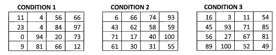
First, convert all three rasters to Boolean images in which a given condition is considered to be satisfied in a pixel if the suitability value is greater than 50%. Then, produce three different MCE results that combine these Boolean conditions in the following three ways and discuss the implications of each of these operations to the riskiness and flexibility of your MCE.
a. Logical AND operation
b. Logical OR operation
c. Ordered weighted averaging, in which the weight is divided equally among the two least suitable conditions at a pixel (0.5, 0.5, 0).
3. Classification is a common goal of remotely sensed image analyses. Describe supervised and unsupervised classification techniques, and discuss how they differ. Suggest how these two types of classifications might be used together in a workflow to produce a superior classification result.
Are You Searching Answer of this Question? Request Australian Writers to Write a plagiarism Free Copy for You.
4. Validation is a key step in the development of a spatial data layer so that its error characteristics can be estimated and reported. Describe how accuracy can be assessed for both quantitative and qualitative datasets, and present four statistics that provide quantitative estimates of accuracy. At least one of these measures should be appropriate for reporting the accuracy of quantitative variables, and at least one should be appropriate for qualitative variables.
5. What are five operations that can be performed in a GIS? Define and provide an example application of each, including a discussion of the data models and variable types that are best suited for each operation.
6. What are the three main processes by which light interacts with materials? Describe how each of these processes contributes to the optical properties of water bodies.
Recent Solved Questions
- NUR3605: Critique best practice principles for governance in the clinical environment. Explain the roles of nurses: Leadership, Governance and Culture Report, ECU, Australia
- GCSCS6004: Describe the level of the conflict and what possible actions could cause it to escalate further: Conflict Management Assignment, Federation University, Australia
- MGT501: Apply conceptual knowledge of reflective practice in a business context and Critically evaluate business principles and stakeholders: Business Environment Assignment, TUA, Australia
- Describe thoroughly the campaign using the terms and notions in integrated marketing communication: Marketing of Management Essay, UM, Australia
- BSBHRM529: Identify and briefly describe each policy and the relevant and applicable legislation for each of the four policies identified in the overview.: Coordinate separation and termination processes Assignment, Australia
- MMM241: Develop a Business Plan for a Business of Your Choice that You would like to Start in the Future: Entrepreneurship and Innovation Assignment, DU, Australia
- Critically Apply Relevant Legal And Ethical Principles To Future Health Care: Professional Transition Essay, USA, Australia
- SITHCCC007: List the Food Safety Aspects Which must be Considered During the Production of Soups Stocks: Prepare Stocks, Sauces and Soups Assignment, VU, Australia
- DESPITE a 56% DECREASE IN the national incidence of sudden infant death syndrome from deaths per 1000 live births in 1992: Epidemiology Assignment, MU, Australia
- SWK316: What this image or content reveals about dominant discourses to violence in contemporary Australian Society: Building Safe Communities Essay, CDU, Australia